Each day, the scene is the same: parents walking with their kids, even their pets, and a few belongings they can carry fleeing from Venezuela.
As the economic, institutional, and social crisis deepens, approximately 4.6 million people have left the country since 2016. While this figure represents around 14% of Venezuela’s total population, this massive influx is changing the landscape of certain cities, as migrants and refugees tend to concentrate in specific areas. Colombia has become the main recipient of this exodus, with Venezuelan migrants and refugees settling in Colombian towns and cities in hope of a better future. Host areas become then “cities of hope” for them, with economic opportunities and social ties being some of the main pull factors for choosing their destination.
In absolute terms, Bogota is the city with the largest number of migrants. However, many Venezuelans have their family, and social or commercial networks in the border areas, preferring to stay in these towns and cities. Others, the most vulnerable, simply lack the resources and remain concentrated along the border. In relative terms, municipalities along the frontier, like Cucuta, are welcoming a disproportionate number of Venezuelans. In these towns and cities between 16% and 38% of the population are from that country.
Despite under-registration and the changing dynamics of migration, the National Census of 2018 shows that Cucuta’s population rose from an estimated 646,468 to nearly 703,000 inhabitants, an increase of 8.74% compared to the projected average growth rate of 0.98% for the period between 2014 and 2018 (see Graph 1).
Graph 1. Cucuta’s population growth and urban expansion over natural coverage (Dane)
")
This considerable influx of migrants is also highly concentrated in specific geographic pockets within cities, mostly in the peripheral suburban settlements. In these areas, sudden and uncontrolled urbanization is limiting the capacity of municipalities to effectively provide public services and conditions for social and economic development.
Migrants and refugees face the same limitations to basic infrastructure and other government services long endured by local communities. Also, the occupation of public space by individuals will further accentuate the city’s lack of shelters and housing, progressively changing the urban landscape. In light of this, cities like Cucuta need to fully assess how this inrush is changing them, and devise policies and investments aimed at integrating migrants in the cities’ urban, social, and economic fabric.
The massive flow of people will test planning tools for inclusive cities that are adaptable to the new demographic and socioeconomic reality. In this sense, it will be key to devise mechanisms for rapidly incorporating migrants and returnees into the job market and for addressing vulnerabilities that can become traps of poverty. This will be crucial to tackling short, medium and long-term challenges and ultimately achieving social stability. It will also play a significant role in the stabilization and development of Colombia, a country that is transitioning out of the longest internal armed conflict in the Americas.
Cities of hope?
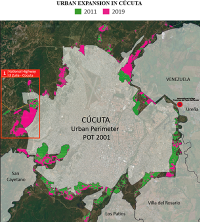
Taking advantage of the World Bank’s partnership with the European Space Agency’s (ESA) under its Earth Observation for Sustainable Development (EO4SD) initiative´s dedicated activity cluster on fragility, conflict, and security, we used satellite imagery, to illustrate the densification beyond Cucuta’s urban perimeter as defined in Municipal Land Use Plan of 2001 (see Map 1).
We found that more and increasingly concentrated settlements can be observed in the peripheral areas bordering with Venezuela and on the west towards El Zulia. The geographical dispersion of settlements makes the provision of basic services costlier and the absence of integrated transport systems hampers access to education and employment. Additionally, the concentration of vulnerable population in sectors with limited infrastructure could be a driver for conflict and spur competition for public services between migrants and host communities.
Map 1: Urban Expansion in Cucuta. Credit: EO4SD-fragility (UNOSAT for ESA/World Bank, 2019)
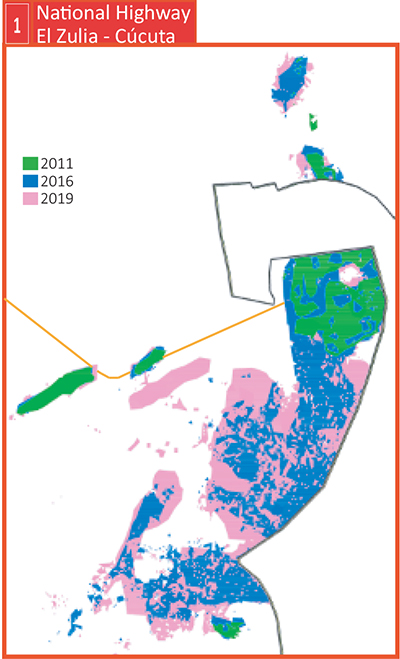
We also found that human settlements are increasingly located in high-risk areas. By contrasting satellite imagery with the land use classification provided by Cucuta Municipal Land Use Plan, we can observe urban expansion beyond the city`s official boundary. The data shows detailed information about settlements established on low and erosional stubble soils unsuitable for building housing on the way out to El Zulia (see Map 2).
Map 2. Detailed areas of urban expansion. Credit: EO4SD-fragility (UNOSAT for ESA/World Bank, 2019)
A geospatial approach
Administrative and population data is fragmented, and Municipal Land Use Plans still do not incorporate quality information on urban integration of migrants and their needs. The use of satellite images and geo-referencing tools can help in the construction of localized data, traffic patterns, and settlement of the population and the harmonization of available data.
The diversity of the migrant population, their diverse needs, and the urban dynamics that this phenomenon gives rise to mean that Cucuta has to adapt quicker than other host cities. In this sense, expansion areas should:
- Adapt their institutional and policy framework to respond, including the design and implementation of medium and long-term strategies for inclusive urban growth for both the pendular, transit population and the migrants with the intention of settling down.
- Expand their response capacity, by expanding the provision of health, education, and housing services among others.
- Mitigate specific vulnerabilities emerging from this shock, including irregularity of migrants, barriers for job placement services and risks of exploitation.
- Work closely with host communities, local authorities, and key actors to build a social contract to welcome and integrate migrants and refugees
The analysis of the protocols for updating land use and improvements in urban planning can create inter-institutional and community synergies that generate innovative and spatial approaches for a comprehensive response to the immigrant community. There is a scope for further research and the integration of technological solutions, such as satellite imagery, can help cities to better understand the impact of massive migration on urban development and the links between urbanism and the prevention of land-related conflicts.
This story was written by Ivonne Astrid Moreno Horta and Paula Rossiasco and first published on December 11, 2019 on the World Bank blog. It can be accessed here: https://blogs.worldbank.org/latinamerica/how-venezuelan-migration-changing-urban-expansion-cucuta-colombia